Welcome to our on-line teaching resources for World Geography (specifically, Europe, Asia, and Africa)!
I call this a link “buffet.” It is not intended that all of these resources be used. It is simply a convenient place to find information, videos, activities, and worksheets by history topic. As is all our lists of links, this page is a work in progress. If you come across broken or outdated links, or if you know of a resource you think should be added, please drop down to the comments to let us know!
Of this list, our children have especially enjoyed Sheppard Software and Seterra for drilling geography memory work on-line. Other activities include geography passports and flag sticker books (earned when the country location is mastered), geography puzzles, and Geopuzzles. These activities allow us to interact more as a family. We also continue to work on map tracing and our free-hand drawings of the continents.
- Make a passport and place a “stamp” in it when each location is mastered. (We purchased the Flags of the World Ultimate Sticker Book and pre-made passports.)
- Make a geography pin map and add the locations throughout the year.
- Use tabletop geography maps for some mealtime fun.
- Make a notebook of national flag coloring sheets. Also create a locator map for each country.
- Study world geography with a missions focus using the book, Window on the World.
- Complete some unit studies, lapbooks, or research reports on select countries of interest. Explore the physical features, monuments, animals, industry, and culture of some of the countries/areas we will be studying.
But more importantly, be sure to practice tracing and drawing maps – and memorizing countries (and even capitals!) at home! Committing to map-drawing practice will prepare your child for memorizing the world more than any other activity or project! Resources for map practice include…
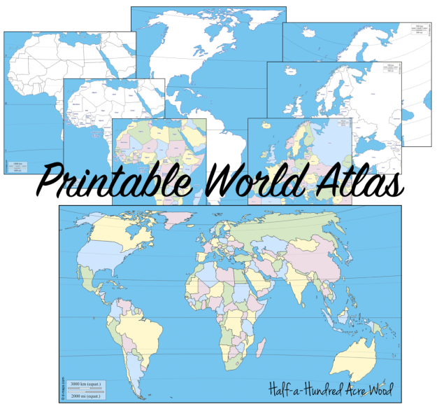
- Map Tracing: A Geography Plan with Printable Atlas
- Practicing country locations and capitals with flashcards
- Learning to draw the major circles of latitude free-hand
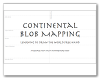
- Learning to draw the world with blob maps
- Learning to draw the world using Chalk Pastels
- Learning to draw using the fantastic continent drawing books by Kristin Draeger

If you’re planning to memorize how to draw the world freehand, we highly recommend the entire Draw the… [Continent] books by Kristin Draeger. We use Draw the World and Draw the USA in our Mission: Great Commission curriculum.
 Draw the World
Learn to draw the world from memory! Draw the World provides students with a simple method of committing a continent outline map of the world to memory. Through simple, step-by-step instructions, students learn to draw each continent as it connects to neighboring continents. This resource is also used in the Mission Pacific Peacemakers Six-Week Unit Study.
Suggested grades: Elementary through High School
Price: $19.95
Format: Paperback.

Fortunately, we’ve already memorized North & South American countries through Kathy Troxel’s Audio Memory Geography Songs CD/Bookletwhich is used in ourMission: World Wonders and Mission: Faith Forgers curriculum.
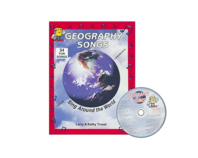
Geography Songs CD, Book, & Map Kit
Memorize the world through song! Divided by geographical regions, these echo-style songs make it simple to memorize the countries of the world. The audio CD includes 34 songs that teach the names of 225 countries, the continents & oceans, and the planets of the solar system. This resource is used in our Mission: World Wonders and Mission: Faith Forgers curriculum.
Suggested grades: Elementary through Middle School
Price: $22.95
Format: Kit consists of an audio CD, a 25″ x 36″ world map with items to label and song lyrics, and a family-reproducible workbook with lyrics and maps. Purchase here on Christian Book Distributors.

After designing curriculum plans for nearly a decade, we’ve embarked on developing a Christian Classical Curriculum that integrates the study of the world and the ongoing fulfillment of the Great Commission, with a focus on loving God, His Word, and fellow mankind. For a reading/curriculum plan that overlaps much of the memory work studied during Cycle 2 – with an integrated study of church history, world history/geography, science, and fine arts, check out our Mission: Faith Forgers Curriculum Plan.
Note: Although Mission: Faith Forgers is not directly correlated to the memory work, it includes a more complete study of astronomy, physical science, and history. The books selected for this reading plan were chosen as long-term resources for students to use when they embark on research and world geography memorization in grades 7+. This study has been designed to be used independently of Classical Conversations®. For families who use Classical Conversations®, the readings assigned in the Mission: Faith Forgers study overlaps much of the memory work studied during Cycle 2 but is not correlated week by week. This provides an opportunity for ongoing review and integration of the memory work throughout the year.
(For those in Classical Conversations, the resources and information in this post may be used with both the Foundations Guide 4th and 5th Editions – CC Cycle 2.) For more resources for world geography, world missions, and world cultures, visit the geography section of our website.
World Geography Resources
General Geography Resources
Window on the World Geography Notebooking Pages
Continental Blob Maps
Map Grids: Latitude and Longitude Activity
How to Draw Major Circles of Latitude Freehand
Map Tracing: A Geography Plan with Printable Atlas
Learn to draw the world freehand ($)
Free Printable Maps with and without labels
Elementary Geography Charlotte Mason Curriculum (free eBooks)
Printable World Maps & Notebooking Pages from Productive Homeschooling
World Geography Printable Coloring Cards
Organizing a Geography Fair
Reviewing Geography with Legos… Beans… and… Trash?
Country Location Worksheets (coloring sheet for notebook)
Passport to Geography
Tabletop Geography
Seterra Software
National Geographic Interactive World Map
Make a geography pin map
Using Photos with PinMaps
Free Pin Map Flags
Expedition Earth: Discovering God’s Animals
ArtMaps
National Geographic MapMaker Maps
Free Montessori World Map
Compass Rose
Lakeside Campground Map (Reading a map)
World Features Map Puzzle
World Landmarks Jigsaw Games
Kathy Troxel Geography Songs Samples
Kathy Troxel’s Audio Memory Video Previews
Cool Country Report
Geography and Country Reports
iPad Apps for World Geography
Stack the Countries
Google Earth
Learn World Geography by Brainscape
National Capitals Genius by Brainscape
Continents & Oceans
Movie & Song for memorizing continents & oceans
Label the World’s Oceans Printable
Free Continent Cards
Continents and Oceans Worksheets
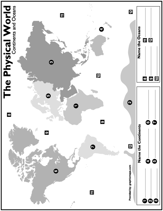
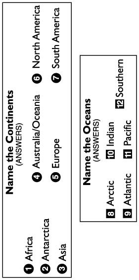
Continents and Oceans Printable Test Map
Continents and Oceans Answers
World Maps
Continents Puzzle Map
World Continents Online Games
Continental Blob Maps
World Biomes Pin Map
National Geographic CopyCat On-Line Continent Game
Papercraft – Build the Globe (UG+)
European Waters
How to Make a Pin Map of Europe
Learn – European Waters Online Learning Interactive
Test – European Waters Online Game
Europe Bodies of Water Seterra online Game
European Countries
Europe Country Location & Capital Flashcards
Draw Europe freehand with Draw Europe $
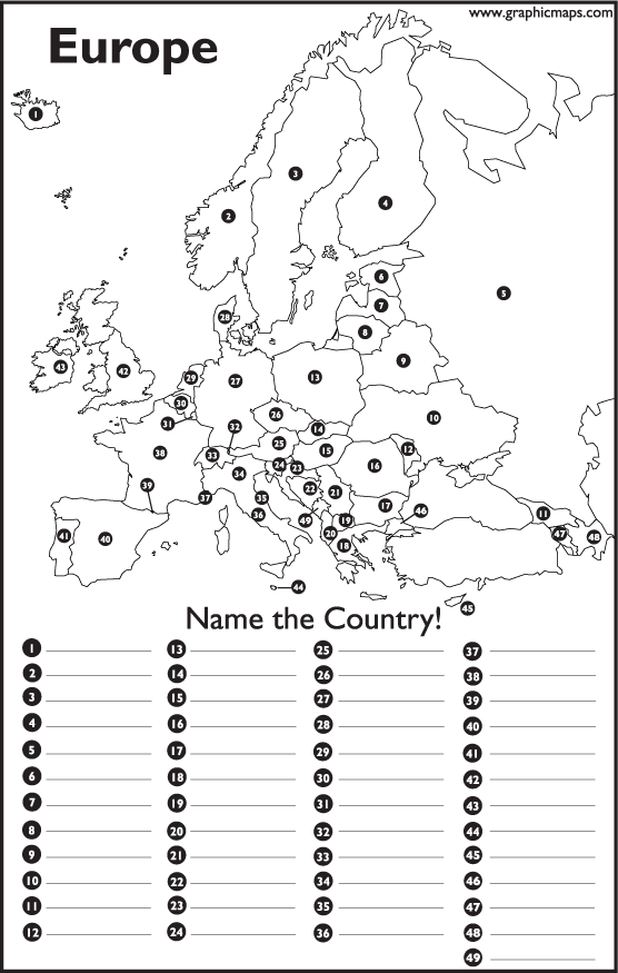
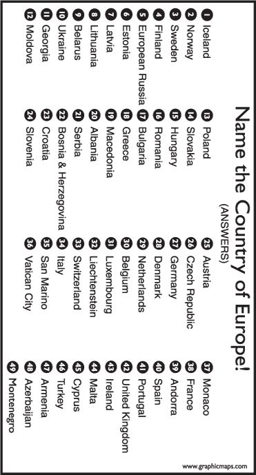
Printable Europe Test Map
Printable Europe Map Answers
Europe On-line Interactive Map
Europe Online Puzzle Map
Europe Online Games
Europe Maps
Ireland Country Lapbook
England Country Lapbook
France Country Lapbook
Spain Country Lapbook
National Geographic Interactive World Map
Love in Many Languages Puzzles
European Rivers
Seterra European Rivers Online Game
Learn – European Rivers Online Learning Interactive
Test – European Rivers Online Game
European Cities
Plot and label cities on Europe Map
Seterra European Cities
Seterra European Capitals
European Mountains
Learn – Geographic Regions Online Interactive
Test – European GeoRegions Online Game
European Peninsulas
Learn – Geographic Regions Online Interactive
Test – European GeoRegions Online Game
Mid-Atlantic World
Explorer Route Maps
Caribbean
Caribbean Country Location & Capital Flashcards
Draw Caribbean freehand $
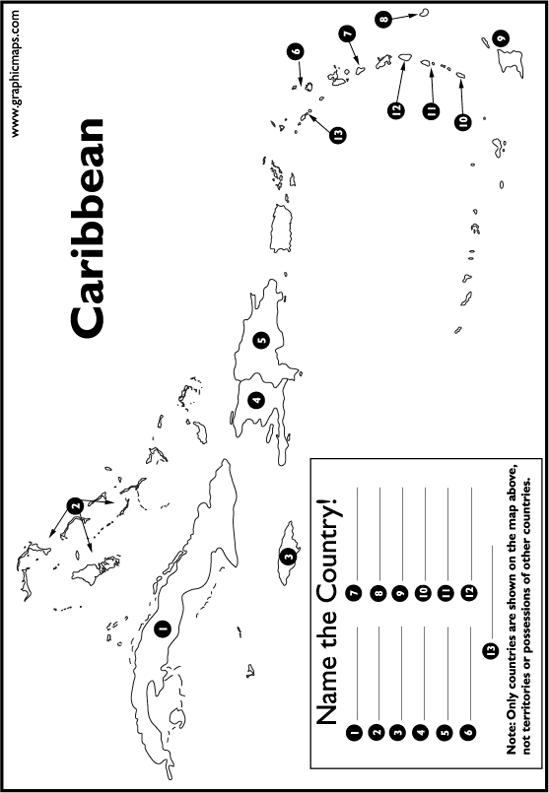
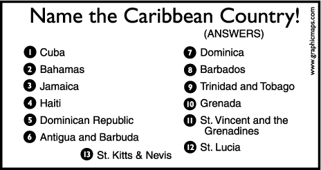
Printable Caribbean Test Map
Printable Caribbean Map Answers
Central America On-line Interactive Map
Central America Online Puzzle Map
Caribbean Online Games
Central America & Caribbean Maps
National Geographic Kids On-line Interactive People and Places
National Geographic Interactive World Map
Southwest Asia
Asia Country Location & Capital Flashcards
Draw Asia freehand with Draw Asia I $
Asia On-line Interactive Map
Asia Online Puzzle Map
Asia Online Games
National Geographic Kids On-line Interactive People and Places
National Geographic Interactive World Map
Asia Maps
Southwest Asia & Middle East Maps
Asia Push Pin Map (in a box)
India Country Lapbook
China Country Lapbook
Eastern Europe (Europe & Asia)
Europe Country Location & Capital Flashcards
Draw Europe freehand with Draw Europe $
Printable Europe Test Map
Printable Europe Map Answers
Europe On-line Interactive Map
Europe Online Puzzle Map
Europe Online Games
Europe Maps
National Geographic Kids On-line Interactive People and Places
National Geographic Interactive World Map
Russia Country Lapbook
Eastern European Seas
Eastern European Seas On-Line Game
Northern European Countries
Europe Country Location & Capital Flashcards
Draw Europe freehand with Draw Europe $
Printable Europe Test Map
Printable Europe Map Answers
Europe On-line Interactive Map
Europe Online Puzzle Map
Europe Online Games
Scandinavian Maps
National Geographic Interactive World Map
Norway Unit Study
Baltic Europe
Europe Country Location & Capital Flashcards
Draw Europe freehand with Draw Europe $
Printable Europe Test Map
Printable Europe Map Answers
Europe On-line Interactive Map
Europe Online Puzzle Map
Europe Online Games
Europe Maps
National Geographic Interactive World Map
Middle East (The Levant)
Asia & Middle East Country Location & Capital Flashcards
Draw the Middle East freehand with Draw Asia I $
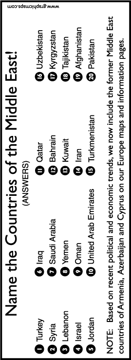
Printable Middle East Test Map
Printable Middle East Map Answers
Middle East On-line Interactive Map
Middle East Online Puzzle Map
Middle East Online Game
Southwest Asia & Middle East Maps
National Geographic Interactive World Map
Balkans
Europe Country Location & Capital Flashcards
Draw Europe freehand with Draw Europe $
Printable Europe Test Map
Printable Europe Map Answers
Europe On-line Interactive Map
Europe Online Puzzle Map
Europe Online Games
Europe Maps
Balkans Maps
National Geographic Interactive World Map
Central Europe
Europe Country Location & Capital Flashcards
Draw Europe freehand with Draw Europe $
Printable Europe Test Map
Printable Europe Map Answers
Europe On-line Interactive Map
Europe Online Puzzle Map
Europe Online Games
Europe Maps
National Geographic Interactive World Map
Switzerland Country Lapbook
Italy Country Lapbook
Southeastern Asia
Asia Country Location & Capital Flashcards
Draw Southeastern Asia freehand with Draw Asia II $
Asia On-line Interactive Map
Asia Online Puzzle Map
Asia Online Games
Kathy Troxel’s Audio Memory Preview of Southeast Asia
National Geographic Interactive World Map
Asia Maps
South and East Asia Maps
South Korea Unit Study
Comparative Geography – Korea vs. Norway Venn Diagram
South Central Asia
Asia Country Location & Capital Flashcards
Draw Asia freehand with Draw Asia I $
Asia On-line Interactive Map
Asia Online Puzzle Map
Asia Online Games
National Geographic Interactive World Map
Asia Maps
South and East Asia Maps
Vietnam Country Lapbook
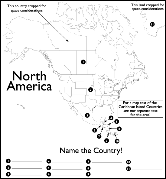
Central America
Central America Country Location & Capital Flashcards
Draw Mexico, Central America, and South America freehand $
Central America On-line Interactive Map
Central America Online Puzzle Map
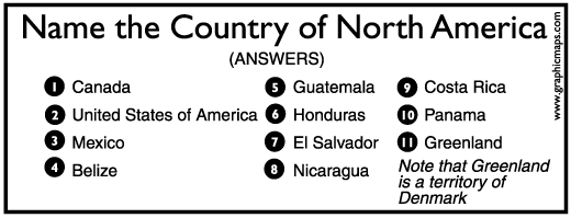
Central America Test Map
Central America Test Map Answers
Central America & Caribbean Maps
South and Central America Geography Games
National Geographic Interactive World Map
Guatemala Country Lapbook
Oceania (5th edition)
Australia & Oceania Countries Capitals Flashcards
Draw Oceania freehand $
Mission Pacific Peacemakers Six-Week Unit Study $
Seterra Oceania Countries & Territories
Oceania Countries Printable Maps & Quizzes
Oceania Capitals
Central/South America (4th edition)
Americas Country Location & Capital Flashcards
Draw Mexico, Central America, and South America freehand $
Central America On-line Interactive Map
Central America Online Puzzle Map
South and Central America Geography Games
Central America & Caribbean Maps
Central America Test Map
Central America Test Map Answers
National Geographic Interactive World Map
Costa Rica Lapbook
Western or Central Asia
Asia Country Location & Capital Flashcards
Draw Asia freehand with Draw Asia I $
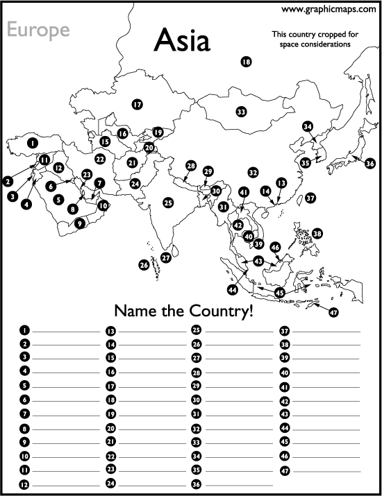
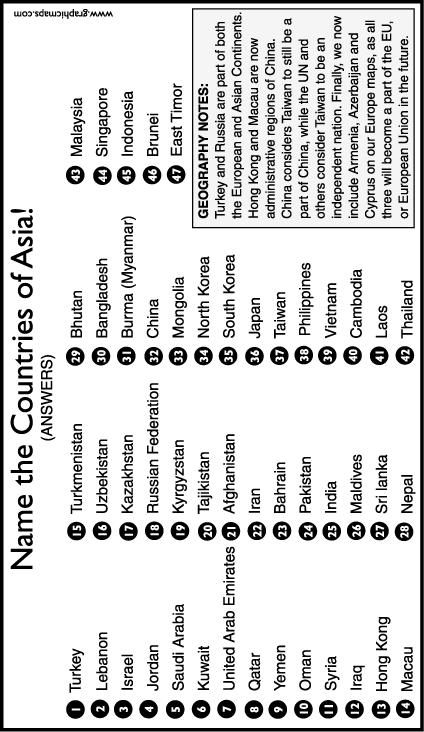
Asia Test Map
Asia Test Map Answers
Asia On-line Interactive Map
Asia Online Puzzle Map
Asia Online Games
National Geographic Interactive World Map
Asia Maps
Western Asia Maps
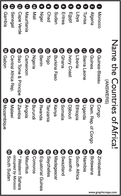
Southern Africa
Africa country locations & capitals flashcards
Draw Africa freehand $
Africa Test Map
Africa Test Map Answers
Africa Maps
Southern Africa Maps
Africa Online Interactive Map
Africa Map Online Puzzle
Africa Online Games
National Geographic Interactive World Map
Africa Cookie Dough Map
For other subjects visit our Cycle 2 Resources Page. Please notify us of broken links by leaving a comment. And if you know of other geography resources that are useful for your family we would love for you to share them in the comments section!
Affiliate links are used in this post.